Soils — Concepts & Soils of India
GS Paper: I (Physical & Indian Geography) + Prelims | Subject: Geography | Teacher: Vaishali Anand (Vajiram & Ravi, Physical Geography Class 1) | Class dates: 30 Jun – 01 Jul 2026 | Last updated: 2026-07-07
How this class is built: the topic is first developed conceptually (what soil is, its composition, profile, and the pedogenic processes of leaching & salt-accumulation) and only then applied to the 8 soils of India (ICAR classification). The teacher stressed that most exam questions come from soils of India, so the concept half exists mainly to explain the properties of each Indian soil. The printed handout covers all 8 soil types (including the two — forest/mountain and peaty — that were not taught in class and were left to a portal video lecture); every handout point is folded in below and tagged
> **HANDOUT:**.
Table of Contents
- What is soil? Pedogenesis
- Properties of soil (physical, chemical, pH)
- Composition of soil (the four components)
- Soil profile & horizons (A, B, C, R)
- Pedogenic processes: translocation, leaching & salt accumulation
- Soil nutrients — N, P, K and the bases
- Soils of India — ICAR (1953) classification
- Laterite soils & laterization
- Alluvial soils
- Black soils (regur / black cotton)
- Red & Yellow soils
- Saline & Alkaline soils
- Desert (arid) soils & calcification
- Forest & Mountain soils (handout / video)
- Peaty soils (handout / video)
- Master comparison table — the 8 soils of India
- Current Affairs
1. What is soil? Pedogenesis
Soil is the uppermost weathered layer of the Earth's crust which supports plant growth. That one line carries two ideas the whole topic hangs on: soil is weathered (it comes from rock broken down into fine particles), and it is defined by its ability to support plant growth (so its fertility and pH matter enormously).
The process of soil formation is called pedogenesis (pedo = soil, genesis = origin/formation). Pedogenesis affects both the composition and the properties of a soil. It is a complex process driven by many factors, and — importantly — every soil undergoes its own pedogenesis, so different soils end up with different profiles, thicknesses and properties. This is why, the teacher noted, there is no single answer to "how thick is soil?" — the depth depends entirely on the pedogenesis a particular soil has been through.
2. Properties of soil
Soils have both physical and chemical properties. The teacher used the board tree below to fix the categories before going into detail.
DIAGRAM (board): the property tree — physical (colour, depth/thickness, texture) vs chemical (pH, fertility) — with the pH scale and the ions that push pH up or down.
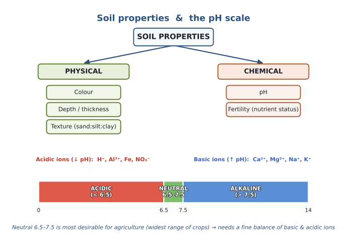
- Physical properties — the simplest examples are soil colour and soil depth/thickness; later we add texture (§3). These are properties often visible to the naked eye, so they act as early indicators of what the soil is likely to be, before any laboratory testing.
- Chemical properties — the simplest example is soil pH; fertility (nutrient status) is the other.
The pH scale (learn the three bands):
| pH range | Reaction | |
|---|---|---|
| < 6.5 | Acidic | |
| 6.5 – 7.5 | Neutral | ← most desirable for agriculture |
| > 7.5 | Alkaline / alkali |
The neutral 6.5–7.5 band is the target for farming because the widest range of crops can be grown in it — food-grains/cereals (rice, wheat), cash crops (cotton, sugarcane), pulses, millets, oilseeds, fruits and vegetables all thrive there. As we'll see in §5, a neutral pH requires a fine balance between the basic ions (which raise pH) and the acidic ions (which lower it).
3. Composition of soil
A soil is made up of four components. For most soils the inorganic (mineral) matter is the bulk, a little organic matter does the rest of the work, and the leftover pore spaces hold air and water.
DIAGRAM (board): the four components in the proportions considered ideal for agriculture — ~45% inorganic matter, ~5% organic matter, ~25% air, ~25% water.
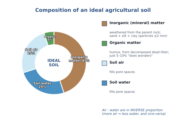
(1) Inorganic (mineral) matter — sourced from the parent material of a parent rock. A parent rock undergoes weathering; small particles/sediments form. Once the particle size is ≤ 2 mm, it becomes the inorganic (mineral) parent material for soil. Anything bigger than 2 mm is gravel (small pebbles/stones) and is not soil. Based on particle size the mineral matter is classified as sand, silt and clay (sand = coarsest, clay = finest).
DIAGRAM (board): the particle-size scale (ISSS) — clay < 0.002 mm, silt 0.002–0.02 mm, sand 0.02–2 mm, gravel > 2 mm.
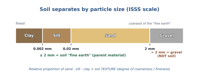
HANDOUT/VERIFIED: ISSS particle-size limits are clay < 0.002 mm · silt 0.002–0.02 mm · fine sand 0.02–0.2 mm · coarse sand 0.2–2 mm · gravel > 2 mm. In speech the two sand fractions are grouped as one "sand" (0.02–2 mm). The load-bearing fact for the exam is the ≤ 2 mm cut-off for soil "fine earth" and clay-finest / sand-coarsest ordering.
The relative proportion of sand : silt : clay is called soil TEXTURE — a physical property, and a measure of the degree of coarseness or fineness of a soil (developed further under black-cotton and red soils, §10–11).
(2) Organic matter — sourced from dead litter (the dead organic matter in soil: dead flora, fauna and microorganisms — soil "behaves like an ecosystem," with biotic components linked to abiotic components through flows of energy and nutrients). Dead litter is decomposed by microorganisms, and at an advanced stage of decomposition an organic material called humus is formed. Humus affects both kinds of property:
- Physical: humus is dark in colour, so humus-rich soils are dark-coloured.
- Chemical: humus improves fertility and also improves the soil's water-/moisture-holding capacity.
Just 5–10% humus can "do wonders" to a soil. How much humus forms depends on the pedogenesis: under forest vegetation it can be ~5–10%; in a desert it is almost negligible (< 1%).
(3) Soil air and (4) Soil water fill the pore spaces. They are present in inverse proportion to each other — if more pore space is filled with air there is less water, and vice-versa.
EXAM FOCUS / most-desirable composition: for agriculture the ideal composition is roughly 45% inorganic matter, 5% organic matter, and 50% pore space split evenly — ~25% air + ~25% water. This is not absolute: for paddy cultivation almost all the pore space is water-filled; and the humus fraction itself varies (forest ~5–10%, desert < 1%).
4. Soil profile & horizons
A soil profile is the vertical cross-section of the entire depth of a soil. It is made up of differentiated horizontal layers called horizons. Within one horizon the properties are similar; between horizons they differ — because pedogenesis acts differently at different depths, so the physical and chemical properties keep changing down the profile.
Why the horizons differ (the humus example): humus comes from the decomposition of dead litter, and dead litter comes from living flora/fauna. Most life-forms live in the shallow, upper layers, so most dead litter — and therefore most humus — is in the shallow upper layer, not deep down. Since humus changes both physical and chemical properties, the upper layer ends up different from the deeper layers.
DIAGRAM (board): the generalised soil profile — A (topsoil) → B (subsoil) → C (unconsolidated bedrock) → R (consolidated bedrock).
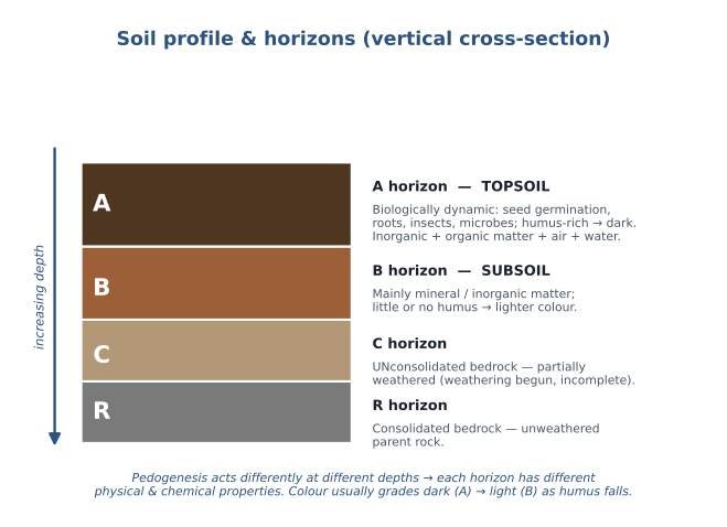
- A horizon (topsoil) — the biologically dynamic layer that supports most of the life of the soil: seed germination happens here, most plant roots are here (few reach the B horizon unless very deep), and the soil's insects, rodents and microorganisms are concentrated here. It contains both inorganic and organic matter (humus), plus air and water. By default, whenever we state a "property of the soil" — its colour, its pH, its fertility, whether it is alkali — we are referring to the A horizon, because the A horizon is where plant growth happens.
- B horizon (subsoil) — primarily mineral / inorganic matter, with little or no humus (some humus can wash down from A, but climatic conditions may leave B with very little or none). Being humus-poor, it is lighter in colour than A.
- C horizon — unconsolidated bedrock, i.e. partially weathered rock: weathering has begun but is not complete. (Complete weathering = the particle size has fallen to sand/silt/clay size, ≤ 2 mm, so it can form soil mineral matter; anything bigger is incomplete/partial weathering.)
- R horizon — consolidated bedrock: weathering has not yet started; this is the un-weathered parent rock (the "bedrock"). Above it the other horizons build up.
Only the A horizon has all the properties needed to support life.
TEACHER'S EXAMPLE (how a soil scientist "reads" a profile): laboratory testing gives the properties with most accuracy, but before the lab, some properties are visible to the naked eye and act as indicators — the clearest being colour. Because A is usually humus-rich (dark) and B is humus-poor (light), the colour difference between A and B tells the scientist where A ends and B begins.
CLARIFICATION (the gradient is not always dark → light): the "A darker than B" rule holds only when humus is the sole factor colouring the soil. If other climatic factors also affect pedogenesis, A can actually turn out lighter than B — so the dark-to-light gradient from A to B is not an absolute statement.
5. Pedogenic processes — translocation, leaching & salt accumulation
This is the conceptual engine of the whole topic: how water moving through the soil redistributes salts, and how climate decides the direction of that movement — which in turn decides whether a soil ends up acidic (leached) or alkaline/saline (salt-accumulated).
Translocation is defined as the downward or upward movement of material through the soil — the vertical movement (not horizontal). Simple examples: some humus falling from A down to B under gravity; or a rabbit burrowing up through the soil and carrying particles from B up to A on its body.
Water is the most effective agent of translocation, because it can move both down and up through the soil, and the direction of its net movement depends on climatic conditions:
- Downward: rainfall/precipitation pulls water down under gravity.
- Upward: under warm temperatures there are evapotranspiration (ET) losses; as the surface dries, capillary action draws water (defying gravity) upward.
So the net direction of water movement depends on the balance of precipitation (P) and evapotranspiration (ET):
DIAGRAM (board): climate controls the direction — humid (P > ET) → net downward → leaching; arid/semi-arid (ET > P) → net upward → salt accumulation.
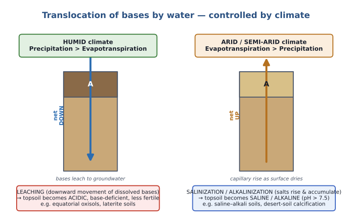
- Humid climate (P > ET): water has a net downward movement. (P and ET can each be any value — what matters is that the inequality P > ET holds.)
- Arid / semi-arid climate (ET > P): water has a net upward movement.
A bit of soil chemistry (which material dissolves & moves?): the mineral composition of a soil depends on its parent rock — a calcareous rock gives a soil rich in calcium salts; an iron-rich rock gives an iron-rich soil; a silica-rich rock gives a silica-rich soil. These minerals are elements (Ca, Mg, Fe, Si …) present in the soil in their ionic form. Some ions raise the soil pH — the basic ions / bases: Ca²⁺, Mg²⁺, Na⁺, K⁺. Some ions lower the pH — the acidic ions: H⁺, Al³⁺, NO₃⁻, iron. A neutral 6.5–7.5 pH therefore needs a balance between the two.
Why bases matter most: of all these ions, calcium and magnesium are the most essential for plant growth — calcium gives the plant structural stability/strength (a plant stands not only because roots grip the soil but because it has structural strength of its own), and magnesium is a component of chlorophyll, without which there is no photosynthesis. So a soil deficient in bases (Ca, Mg) is considered poor in nutrients / infertile.
The decisive fact: bases are more soluble in water than the acid-generating ions, so bases readily dissolve and get translocated with the water. What this does to a soil depends on the climate:
Leaching is defined as the downward movement of material through the soil in a dissolved state. Under a humid climate (net downward water) the readily-soluble bases get leached downward — they percolate down through the horizons and end up dissolved in the groundwater aquifer. Result: the A horizon is left rich in acidic compounds → the soil becomes acidic, base-deficient, low in fertility, with limited agriculture potential. Under humid conditions, leaching will always take place.
TEACHER'S EXAMPLE (river water vs groundwater): compare river/canal water (which we use for irrigation & cities) with groundwater (also used for drinking). Groundwater always has more salts — because salts dissolve in water and come to rest, in dissolved state, in the groundwater aquifer. That is exactly where leached bases go.
TEACHER'S EXAMPLE (equatorial soils = classic leaching, and a favourite true/false trap): the equatorial belt (0°–10° N & S) has a humid climate → soils there undergo intense leaching → highly acidic, base-deficient, nutrient-poor, limited agriculture potential. These are the oxisols. Then why does the luxuriant equatorial rainforest (e.g. the Amazon/Brazil) grow on them? Not because the soil is fertile — the dense growth is driven by the warm temperature + humid conditions, and the natural vegetation has evolved special adaptations for nutrient-deficient soils (the specific adaptations are covered later, in Biomes, in the Environment section). India has no oxisols; they were introduced only as the textbook example of leaching.
CLARIFICATION (sunlight ≠ temperature): don't assume the equator has the highest ET just because it is sunny. ET depends on temperature, not sunlight, and sunlight and temperature are different things — the poles get 24-hour daylight in summer yet stay too cold for any effective ET. At the equator ET can be very high, but precipitation is even higher, so P > ET holds, leaching happens, and the soil is acidic.
(The mirror process — salt accumulation under arid/semi-arid climates, i.e. salinization & alkalinization — is developed fully with the saline-alkali soils in §12.)
6. Soil nutrients — N, P, K and the bases
Across almost all Indian soils, a common refrain is that nitrogen is low, while phosphorus and potash vary with the parent rock. The reason lies in the type of biogeochemical cycle each nutrient follows.
DIAGRAM (board): why soils are usually poor in N (a gaseous cycle, reservoir in the atmosphere) while P and K (sedimentary cycles) depend on the parent rock.
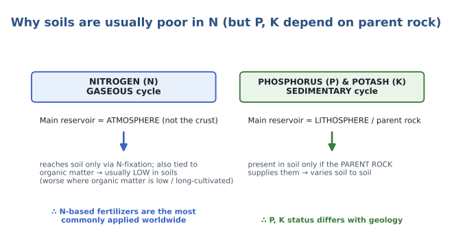
- Nitrogen (N) — a gaseous cycle. Its fundamental reservoir is the atmosphere, not the lithosphere/crust. N reaches the soil only via nitrogen fixation, and its soil availability also depends on the soil's organic matter. So N is generally low in soils — and it falls further where organic matter is low, or where land has been under agriculture for a long time (agriculture drastically changes a soil's natural properties and depletes organic matter over the years). This is why nitrogen-based fertilizers are the most commonly applied fertilizers worldwide.
- Phosphorus (P) & Potash (K) — sedimentary cycles. They depend on the parent rock: if the parent rock has P and K, the soil has them; if the parent rock is deficient, so is the soil. Hence P and K status varies from soil to soil.
- Bases likewise come from the parent rock — but even a base-rich rock can leave a base-poor soil if leaching has washed the bases down (as in laterite).
EXAM FOCUS (how NCERT frames true/false statements): the teacher pointed out that the handout's soil statements are lifted from NCERT, and NCERT mentions "manuring / fertilization needed" only for soils that are inherently infertile; for naturally fertile soils it stays silent. Do not read that silence as "no fertilizer needed" — with modern intensive agriculture, every soil (even fertile alluvium) needs fertilization. NCERT's wording only distinguishes natural fertility.
7. Soils of India — ICAR (1953) classification
The soils of India were classified by the Indian Council of Agricultural Research (ICAR) — through its All-India Soil Survey Committee — in 1953, on the basis of genesis, colour, composition and location, into eight major types:
- Alluvial soils
- Black soils (regur / black cotton)
- Red & Yellow soils
- Laterite soils
- Forest & Mountain soils
- Arid / Desert soils
- Saline & Alkaline soils
- Peaty (& Marshy) soils
VERIFIED: the "ICAR 1953" date and the eight-fold classification are correct (the All-India Soil Survey Committee, 1953). The class taught six of these — laterite, alluvial, black, red, saline-alkaline and desert; the remaining two (forest/mountain and peaty) are in the handout and were assigned to a portal video lecture — both are included in full at §14–§15.
The class began with laterite (out of order) because its formation, laterization, needs the leaching concept from §5.
8. Laterite soils & laterization
Laterite soils are formed by the process of laterization.
HANDOUT / board definition: Under tropical monsoonal climate (warm & humid conditions), in regions of plateau or upland topography (elevation ~900–1500 m), there is rapid weathering and intense leaching of the parent rock. Silica in the soil becomes mobile and is leached down along with the bases; the upper horizon becomes concentrated in acidic ions and in the oxides of iron and aluminium, forming hard, thick lateritic pans. The process is laterization and the soils are laterite soils.
Role of climate. Laterization needs a tropical monsoonal climate with alternate wet and dry seasons but which stays warm and humid almost throughout the year — exactly India's climate (summer = wet season, winter = dry season, warm-humid overall). Warm + humid ⇒ rapid weathering, and humid ⇒ leaching, so the bases are leached downward (as in §5).
Role of weathering — a detour into the Earth's crust. To see what happens to silica, recall the crust's composition:
DIAGRAM (board): elemental composition of the Earth's crust by weight — O ≈ 47%, Si ≈ 28%, Al ≈ 8%, Fe ≈ 5%, Ca ≈ 4%, Mg ≈ 4%.
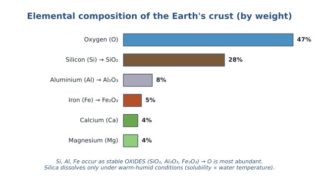
- The descending order by weight is Oxygen (47%) → Silicon (28%) → Aluminium (8%) → Iron (5%) → Calcium ≈ Magnesium (~4% each).
- Oxygen is most abundant because the top elements exist as stable oxides — silicon as silica SiO₂, aluminium as Al₂O₃, iron as Fe₂O₃. Oxygen readily oxidises whatever it contacts, so these elements sit in oxidised form and oxygen dominates the weight.
CLARIFICATION (silica vs silicon; and "SIAL/SIMA" is outdated): the element is silicon; silica is its oxide, SiO₂. When asked for the element the answer is silicon, but it is present as silica. Because these top oxides are so abundant on the crust despite the crust having been weathered for millions of years, they must be chemically quite stable / resistant to weathering — which is also why the old "SIAL / SIMA" layering idea is an outdated understanding.
- Stable, but not inert. Silica can undergo chemical weathering under special conditions: the solubility of silica in water is directly proportional to the temperature of water. So under persistent warm + humid conditions (good rainfall + warmth), silica dissolves in water and is leached down — this is the chemical weathering of silica, called de-silication.
Putting it together — laterization is three things happening at once:
DIAGRAM (board): the laterite profile — silica and bases leach down, iron & aluminium oxides (sesquioxides) concentrate in the upper horizon as a hard lateritic / iron pan.
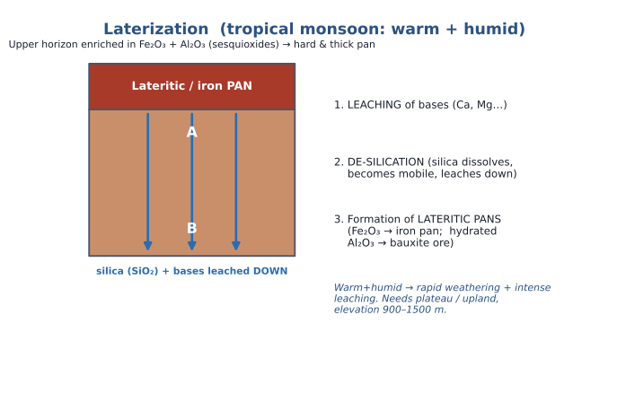
- Leaching of bases (Ca, Mg …) downward.
- De-silication — silica dissolves, becomes mobile and is leached down from the A horizon.
- Formation of lateritic pans — once silica and bases are gone, the upper horizon is left concentrated in oxides of iron and aluminium (Fe₂O₃, Al₂O₃ — the "sesquioxides"), which accumulate as hard, thickened layers = lateritic pans.
Role of topography (why 900–1500 m). The elevation controls how thick the pan gets:
DIAGRAM (board): more elevation → thicker crust → more accumulated Fe/Al oxides → thicker pan; but above ~1500 m the climate turns sub-tropical and the whole process stops.
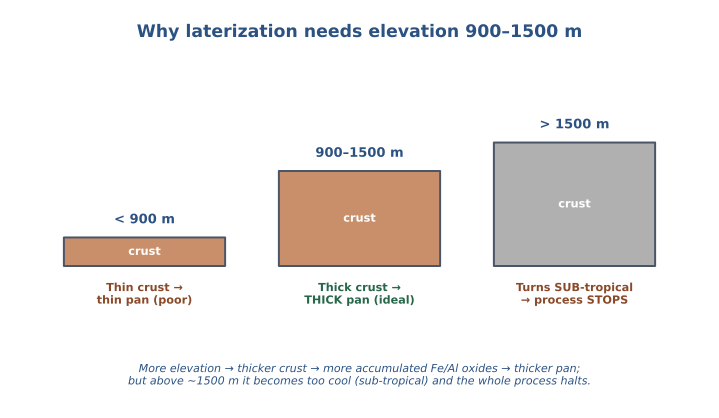
- We don't need tall mountains (Himalaya) or flat land (Indo-Gangetic plains) — we need plateau / upland at ~900–1500 m. Comparing two tropical-monsoon sites at the same climate: the one with greater elevation has a thicker crust, and after de-silication removes silica, more iron & aluminium oxide is left behind in absolute terms, forming a thicker, harder pan.
- Why not above 1500 m? More elevation gives a thicker crust (better pans), but above ~1500 m the climate changes from tropical to sub-tropical, and in a sub-tropical climate the whole process halts — laterization needs a tropical climate. Hence the upper limit of ~1500 m.
Commercial significance — bauxite & iron pans. The pans are chemically iron oxide + aluminium oxide. Where iron oxide is locally concentrated we get an iron pan; where aluminium oxide is locally concentrated and hydrated (holds water), it forms bauxite — the ore of aluminium. So India's bauxite reserves are a consequence of laterization. The iron pans are structurally very strong: they are excavated whole, cut into small blocks called bricks, and used in building construction — so laterite has value in the construction and industrial sectors even though its farming value is limited.
Distribution & a geography tangent (Meghalaya plateau).
HANDOUT — distribution: ~8% of TGA; Peninsular highlands of the Western Ghats (above ~1000 m) and Eastern Ghats, Rajmahal Hills, Vindhyas and Malwa Plateau; commonly in Karnataka, Kerala, Tamil Nadu, Madhya Pradesh and the hilly areas of Odisha and Assam; and in north-eastern India over the Meghalaya plateau. Wherever India has tropical-monsoon plateau/upland (Eastern & Western Ghats, Meghalaya upland, Malwa & Chota Nagpur plateaus), laterization has occurred.
DIAGRAM (board) / map: the Meghalaya plateau is a detached eastern piece of the Peninsular plateau — its western range is the Rajmahal Hills, its counterpart across the gap is the Garo Hills, and the depression between them (the Rajmahal–Garo / Malda gap) was filled by Ganga–Brahmaputra sediments.
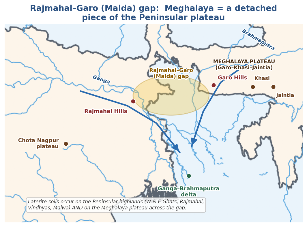
The Meghalaya (Garo–Khasi–Jaintia) plateau is an extension of the Peninsular plateau that got dis-integrated from it. The Peninsular plateau's easternmost range here is the Rajmahal Hills; the piece that drifted away (northward) is today's Meghalaya plateau, whose western range is the Garo Hills. Between them a depression / low-line area formed — the Rajmahal–Garo gap (also called the Malda gap) — and the Ganga and Brahmaputra, following the slope, flowed into it, deposited their sediments, and built the vast Ganga–Brahmaputra delta that fills the gap and drains into the Bay of Bengal. Laterite soils occur on the Meghalaya plateau just as on the Peninsular highlands.
BOUNDARY CAVEAT (for Mains map answers): the base map is a community/GoI-style outline used as a study aid; the river courses shown are schematic.
HANDOUT — properties: laterite soils are acidic, pH 5–6; poor in organic matter, nitrogen, phosphate, potash, and in the bases magnesium & calcium; adequate in iron oxide; and reddish in colour (from the iron oxide / iron pans). Being leached, they have limited agriculture potential.
HANDOUT — crops: with manures & irrigation, best suited to plantation crops — tea, coffee, rubber, cashew, coconut, arecanut — and they are widely cut as bricks for house construction.
9. Alluvial soils
Alluvial soils are formed by the transportation and deposition of sediments in low-lying areas by the action of water — so they are depositional in nature. (Globally these are "alluvial"; the Indian name is the same.)
The mechanism: rocks are eroded by an agent (here water); the sediments are transported and then deposited far away, where they become the parent material for soil. Water acts as this agent in two ways — as rivers, and, along coasts, as waves and tides.
DIAGRAM (board): rivers deposit coarse alluvium at the Shivalik foothills (heavy sediments drop first) and progressively finer alluvium toward the delta (finest carried farthest) → texture is variable.
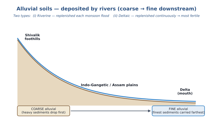
Two types:
- (i) Riverine alluvial — Himalayan rivers have high erosive capacity while descending the steep Himalaya; once the gradient gentles in the plains, deposition takes over, building the vast Indo-Gangetic plains and the Assam plains of the north-east.
- (ii) Coastal / deltaic alluvial — Peninsular rivers flow through hard rock (so erode much less), but by the time they reach their mouths the gentle gradient triggers deposition, building deltas — Ganga–Brahmaputra, Godavari, Krishna, Mahanadi, Kaveri — where waves, tides and rivers all deposit sediment. In Gujarat, the small alluvial tract is built by the Narmada and Tapi.
Why alluvium is fertile — regular sediment replenishment. Sediments are the source of many minerals carried from upstream rocks, and alluvial soils get them replenished regularly:
- Riverine: every year during the monsoon floods, fresh sediment is laid over the plains — replenishment once a year.
- Deltaic: at the delta the river deposits continuously, non-stop as it drains to the sea — replenishment never stops, so deltaic alluvium is even more fertile than riverine. The teacher called good alluvium "pure gold for agriculture."
Texture is variable (unlike black cotton or red soil, where a single texture is named). At the Shivalik foothills the river drops the heavier, coarser sediments first (coarse alluvium); by the delta only the finest sediments remain (fine alluvium). Because no single texture applies, texture is simply not stated for alluvium.
HANDOUT — distribution & properties: covers ~45–46% of India's TGA; occurs in Northern, North-Eastern & Peninsular India — extensive over the Indo-Gangetic plains from Punjab (west) to West Bengal (east), the Assam plains of the Brahmaputra, the Gujarat plains of the Narmada & Tapi, and the deltas of the Mahanadi, Godavari, Krishna & Kaveri. Generally adequate in potash, poor in phosphorus & nitrogen, adequate in bases; depositional and fertile (regular sediment replenishment for both deltaic and riverine); intensively cultivated; neutral pH 6.5–7.5; helped further by abundant groundwater aquifers.
HANDOUT — crops: everything — cereals (wheat, rice); cash crops (sugarcane, cotton, jute, tobacco); oilseeds (mustard); fruits & vegetables.
EXAM FOCUS (two Prelims question-formats, per the teacher): (1) "In the context of X soils, which of the following statements are correct?" — a set of 4–5 statements to verify; (2) properties given → identify the soil from four options. Learn each soil's identifying property for format (2).
10. Black soils (regur / black cotton)
Called black soils because they are black; black cotton soils because they are excellent for cotton; and regur locally in India.
HANDOUT / board — formation: formed by the weathering and disintegration of basaltic lava rocks associated with volcanic eruptions of Cretaceous times (~66 million years ago).
The Deccan-Traps story. Around 66 million years ago the Indian (Peninsular) plate — which had broken off Gondwana and was drifting north (it still is, colliding with Eurasia to raise the Himalaya) — sat over the Réunion hotspot in the Indian Ocean. Hotspots are sites of intense volcanism, and the lava they erupt is basaltic — a chemical composition rich in iron, magnesium and titanium. The lava collected on the Indian plate, cooled and solidified into igneous basaltic lava rocks; this part of the Peninsular topography is the Deccan Traps. The plate then drifted north, and over millions of years the basalt weathered into the black cotton soil.
CLARIFICATION (year): the class audio transcript reads "665 million years", which is a transcription error — the correct age is ~66 million years ago (Cretaceous–Palaeogene boundary), produced by the Réunion hotspot (the board itself notes "66 million"; verified against standard geology).
CLARIFICATION (dark colour ≠ humus): black-cotton soil is dark not because of humus but because its parent rock is dark (rich in titanium, iron, magnesium). Dark soil colour can come from humus or from a dark parent rock — an important exam distinction.
Texture — the identifying property. Black cotton is clay-textured (the clay mineral is montmorillonite, over 60% of particles). Texture links to water behaviour:
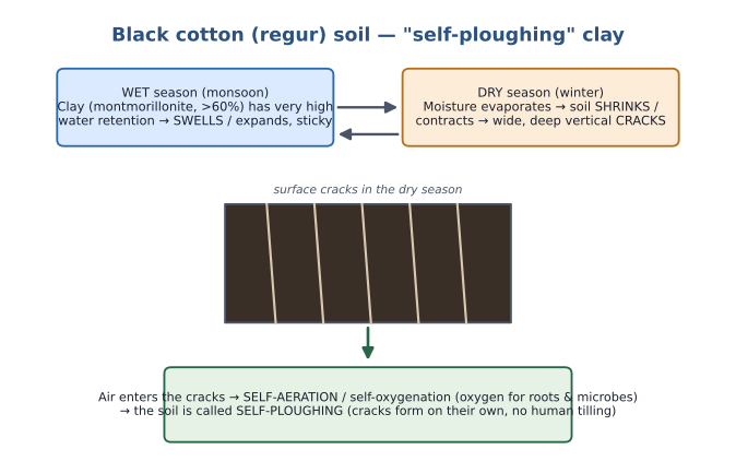
DIAGRAM (board): the wet-swell / dry-shrink cycle that makes black-cotton soil "self-ploughing".
- Texture rule: a fraction "dominates" when it exceeds 50%. Sand-dominated ⇒ sandy; silt-dominated ⇒ silty; clay-dominated ⇒ clayey.
- Moisture-holding capacity is inversely proportional to particle size — finer particles hold more water. So clay > silt > sand in water-holding. Being clay-textured, black cotton has very high water-holding capacity.
- Soil drainage = the ability of water to flow down through the soil. High water-holding means water is locked in the pore spaces and cannot flow down freely ⇒ black cotton is poorly drained.
- Self-ploughing: black-cotton soils sit in a tropical monsoonal climate (alternate wet & dry seasons). In the wet season they absorb water and swell/expand; in the dry season the moisture evaporates and they shrink/contract, opening wide, deep vertical cracks all over the surface. Because the cracks form on their own (no human tilling), this is self-cracking; air then enters the cracks, giving self-aeration / self-oxygenation — hence the soil is called self-ploughing (self-ploughed). Aeration is beneficial because soil life (roots, microbes, fauna) needs oxygen for respiration (and the incoming air also brings nitrogen); we always call this oxygenation. (Humans achieve the same aeration by ploughing; here it happens naturally.)
HANDOUT — properties: ~16–17% of TGA (the 2nd most widespread Indian soil), in regions of high temperature & low rainfall; fine-textured, clay (montmorillonite) > 60% ⇒ poorly drained; black (iron in the parent material + a small proportion of titaniferous magnetite; colour deep-black to grey); rich in lime (Ca/bases), magnesium, potash, iron and alumina; pH 7.2–8.5; lacking in phosphorus, nitrogen and organic matter; retains moisture very well (swells & becomes sticky when wet, shrinks & cracks when dry — the "self-ploughing"), which helps especially rain-fed crops sustain through the dry season.
CLARIFICATION (pH): the class audio said "7.2 to 7.5"; the printed handout says 7.2 to 8.5. Use the handout value, pH 7.2–8.5 (neutral-to-alkaline). This fits the parent rock: basalt is neutral-to-basic, so the soil is neutral-to-basic too.
HANDOUT — distribution: Peninsular India — Maharashtra, MP (Malwa Plateau), parts of Karnataka, Andhra Pradesh, Telangana, Gujarat and Tamil Nadu.
HANDOUT — crops: especially cotton (hence "black cotton"); sugarcane where irrigation is available; also wheat, jowar, millets, sunflower, linseed, tobacco, and fruits & vegetables.
EXAM FOCUS: if a Prelims "identify the soil" question lists "clay-textured" as a property and all options are Indian soils, the answer is almost certainly black cotton — no other Indian soil is identified so strongly with clay texture.
11. Red & Yellow soils
Called red soils (or red and yellow soils) because they range from reddish to yellowish.
HANDOUT / board — formation: formed by the weathering and disintegration of ancient granitic and gneissic rocks.
Besides basaltic lava, Peninsular India also has granite (an igneous rock) and gneiss (a metamorphic rock — granite metamorphoses into gneiss). Their origin goes back to Gondwana: the Peninsular plate carried Gondwana's rocks, and granite and gneiss are very hard and resistant to weathering, so — given the very long time available — they slowly weathered into the parent material of red soils.
Colour. These rocks are reddish because iron (as ferrous oxide) is well-distributed throughout them — iron oxide is not abundant, but it is well diffused, which gives the red tint. When the iron oxide is hydrated (kept moist), it turns yellowish — hence "red and yellow", depending on the degree of hydration.
Texture — loam.
HANDOUT / board: red soils are loam-textured, and therefore well-drained. Loam is a texture in which none of sand, silt or clay dominates (none exceeds 50%), so it is also called "evenly textured". Loam itself has varieties (e.g. 40:40:20, 20:40:40, or ~⅓ each) — all count as loam as long as nothing dominates.
Compared with black cotton (definitely fine/clay), red soil is relatively coarser; loam does not hold much water, so it is well drained (black cotton was poorly drained).
pH. The parent rocks granite/gneiss are neutral-to-acidic, so the red soils are neutral-to-acidic too. (Contrast: black cotton's basalt was neutral-to-basic.)
HANDOUT — properties & distribution: ~10–11% of TGA, spread in small pockets across many states wherever the Peninsular rocks occur — Tamil Nadu, parts of Karnataka, south-east Maharashtra, eastern Andhra Pradesh, Telangana, MP, Chhattisgarh, Odisha, the Chota Nagpur plateau of Jharkhand & southern Bihar; Birbhum & Bankura (West Bengal); Mirzapur, Jhansi, Banda & Hamirpur (UP); Rajasthan east of the Aravallis; and parts of Assam, Nagaland, Manipur, Mizoram, Tripura & Meghalaya. Colour red → yellow (red from diffused iron, yellow from hydrated ferrous oxide); generally poor in nitrogen, phosphorus, lime and humus; neutral-to-acidic; adequate in potash; well-drained (loam).
HANDOUT — crops: fertilizers needed for cultivation; suited to cotton, pulses, millets, oilseeds, potato, tobacco & fruits. (Less fertile than alluvium/black-cotton, but it does have agricultural potential and suits less-water-requiring crops — millets, pulses, oilseeds.)
TEACHER'S ASIDE (glei/gley soils, briefly): a student asked about "clay/glei" soils. These are not defined by texture. In low-lying, high-rainfall areas the water table rises, the soil becomes water-logged and turns clayey → a glei (gley) soil — a consequence of the water-table position, not of texture. (The teacher said "forget it if it didn't land" — it is not part of the ICAR-8.)
12. Saline & Alkaline soils
These are the mirror-image of leaching: they form where water moves up and salts are left behind at the surface.
HANDOUT / board — formation: Under arid & semi-arid climates there is a strong capillary attraction of dissolved salts (of calcium, magnesium, potassium and sodium) toward the drying-out surface of the soil. As moisture evaporates, the salts accumulate in the upper horizon — the process is salinization and alkalinization.**
DIAGRAM (board): capillary rise of salts under ET > P, the salt crust / salt pans, and the chemistry that separates salinization from alkalinization.
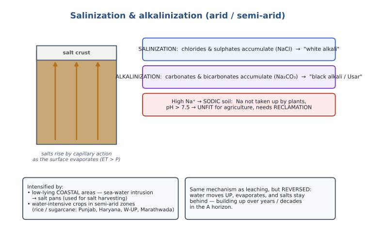
Because the climate is arid/semi-arid, ET > P, so water has a net upward movement (§5). Bases dissolve, are carried up by capillary action, the water evaporates, and the salts pile up in the A horizon until pH rises above 7.5. Two names, same mechanism but different chemistry:
- Salinization — chlorides & sulphates accumulate (e.g. NaCl) → surface white encrustation → "white alkali".
- Alkalinization — carbonates & bicarbonates accumulate (e.g. Na₂CO₃), soil is non-porous → "black alkali" / "Usar".
Why sodium is the villain. When the accumulating salts are of Ca, Mg, K, the plants absorb them for their own growth, which pulls the pH back toward neutral (a high pH from excess Ca/Mg is less problematic). But sodium (Na) is only a trace element — plants don't need it and won't take it up — so Na stays in the soil, distorting the pH balance. A soil with high sodium is a sodic soil, its pH exceeds 7.5, and it is unfit for agriculture and needs reclamation — i.e. the pH must be restored to the neutral range before farming.
What intensifies it:
- Natural — low-lying coastal areas (arid/semi-arid): waves and tides bring sea water (rich in salts) inland; the water evaporates (ET > P) and salts remain, building up over years until a thick surface salt pan forms. These salt pans are used for salt harvesting (e.g. natural salt pans on the Gujarat coast).
- Human — wrong crop choice: growing water-intensive crops (rice, sugarcane) in semi-arid regions leads farmers to over-irrigate. Irrigation leaches salts down only temporarily; the climate (ET > P) keeps pulling salts back up, and after years/decades enough salt accumulates to push pH > 7.5 and render the land unfit. Real Indian cases: Marathwada (Maharashtra) under sugarcane, and Punjab, Haryana & western UP under rice & sugarcane — where salinization has become acute and soils need reclamation.
HANDOUT — properties: cover < 5% of TGA; contain a large proportion of sodium, potassium and magnesium ⇒ infertile, support no vegetative growth; lack nitrogen. Saline soil shows a white encrustation of salts (chlorides & sulphates of Na, Ca, Mg) in summer from high evaporation — the "white alkali soil", formed by saline irrigation water and long over-irrigation of poorly-drained areas. Alkaline soil is rich in carbonates & bicarbonates of sodium and is non-porous — the "black alkali" or "Usar" soil. Local names: Usara, Reh (Punjab), Kallar, Chopan, Thur, Karl. All need reclamation for crop growth.
HANDOUT — distribution: semi-arid Punjab, Haryana & western UP; drier Rajasthan & Gujarat (climatic); Maharashtra (mainly Marathwada, from sugarcane); and some coastal areas (sea-water intrusion).
13. Desert (arid) soils & calcification
Desert soils are formed by the transportation and deposition of loessic sediments by the action of wind — so they are depositional.
HANDOUT / board: formed by transportation & deposition of loessic sediments by winds — the local winds of the Indus basin and the south-west monsoonal winds.
Of the eight Indian soils, two are depositional: alluvial (agent = water) and desert (agent = wind). Wind-transported sediment is called loess (loessic sediment).
Calcification & the kankar layer. In certain desert areas a special process, calcification, operates:
DIAGRAM (board): CaCO₃ shuttling A ⇄ B under a semi-arid climate, building an impermeable kankar layer in the B horizon.
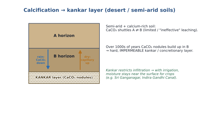
Calcification needs two things together — a semi-arid climate and a soil with plenty of calcium carbonate (CaCO₃). Under semi-arid conditions there is some rain, but leaching is limited / "ineffective". When it rains, the CaCO₃ (the active salt) moves down from A to B; when the soil dries, capillary forces carry it back up from B to A. Over thousands of years this two-way shuttle deposits CaCO₃ as small nodules that accumulate in the B horizon, forming a hard, impermeable layer of calcium-carbonate nodules called kankar (locally) or the concretionary layer. Once this layer forms, water can no longer drain below it, so water movement is confined between A and B.
HANDOUT — properties: ~4–5% of TGA; generally saline; the dry climate, high temperature and accelerated evaporation leave them short of moisture and humus/organic matter; nitrogen is insufficient but — uniquely — phosphate content is normal (the teacher flagged this as the only Indian soil where phosphate is normal; in all others phosphate is deficient); the lower horizons carry the "kankar" layer from increasing calcium downward, which restricts water infiltration — so when irrigation is provided, soil moisture stays readily available near the surface for sustained plant growth.
KEY INSIGHT (moisture, not nutrients, is the limiter): nutrient-wise these soils are actually decent (they have CaCO₃ and normal phosphate). Their biggest limiting factor is moisture deficiency, not nutrient deficiency. So with irrigation they give good yields — e.g. Sri Ganganagar district (Rajasthan), a desert-soil area, became productive once the Indira Gandhi Canal command network brought irrigation. But the crop must match the climate: grow water-intensive crops in this semi-arid land and, as in Punjab, salinization eventually sets in — so sustainable agriculture needs a climate-compatible crop choice.
HANDOUT — distribution & crops: in arid & semi-arid Rajasthan (Thar, west of the Aravallis), with extensions into parts of Gujarat, Haryana & Punjab. Reclaimed by irrigation in the Indira Gandhi Canal command area; suited to drought-resistant crops — barley, rapeseed, millets, pulses.
14. Forest & Mountain soils
HANDOUT — (to be elaborated in the portal VIDEO lecture; not taught in class). These were assigned by the teacher to a video lecture along with peaty soils and a short discussion of "soil problems."
- Cover ~9% of TGA. Found in forest areas with sufficient rainfall — the forested Himalayan region, and the forested parts of the Western & Eastern Ghats.
- Rich in humus but poor in potash, phosphorus & lime; low in bases and slightly acidic.
- Crops: temperate fruits in Jammu & Kashmir, Himachal Pradesh & Uttarakhand; in the warmer states of Kerala, Karnataka & Tamil Nadu, plantation crops & tropical fruits; also wheat, maize, barley.
15. Peaty soils
HANDOUT — (to be elaborated in the portal VIDEO lecture; not taught in class).
- Occur in areas of heavy rainfall & poor drainage. Found in < 5% of TGA — coastal Odisha, Tamil Nadu, the Sundarbans of West Bengal; called "Kari" soils in Kerala; with isolated pockets in Uttarakhand & Bihar.
- A large quantity of dead organic matter accumulates, giving a rich humus/organic content — organic matter can reach 40–50%. Black in colour and highly acidic. Deficient in potash & phosphates.
- Crops: suited to paddy cultivation.
16. Master comparison table
The eight ICAR soils at a glance (percentages of Total Geographical Area from the handout). Texture & pH are the usual "identify-the-soil" hooks.
| Soil | ~% TGA | Formed from / agent | Texture | pH | Nutrient notes | Key crops | Core distribution |
|---|---|---|---|---|---|---|---|
| Alluvial | 45–46 | Deposition by water (rivers, waves/tides) | Variable (coarse→fine) | Neutral 6.5–7.5 | +Potash, +bases; −P, −N | Rice, wheat, sugarcane, cotton, jute | Indo-Gangetic & Assam plains; Peninsular deltas; Narmada–Tapi (Gujarat) |
| Black / regur | 16–17 | Weathering of basaltic lava (Deccan Traps, ~66 Ma) | Clay (montmorillonite >60%) → poorly drained | 7.2–8.5 (neutral–basic) | +Lime, Mg, potash, Fe, alumina; −P, −N, −OM | Cotton, sugarcane (irrig.), jowar, millets | Maharashtra, MP (Malwa), Karnataka, Andhra, Telangana, Gujarat, TN |
| Red & Yellow | 10–11 | Weathering of granite & gneiss | Loam ("evenly") → well drained | Neutral–acidic | +Potash; −N, −P, −lime, −humus | Millets, pulses, oilseeds, cotton, potato | Small pockets across the Peninsular-rock states |
| Laterite | ~8 | Laterization (leach + de-silication) on tropical-monsoon uplands 900–1500 m | — (Fe/Al-oxide pans) | Acidic 5–6 | +Iron oxide; −OM, N, P, K, Ca, Mg | Plantation: tea, coffee, rubber, cashew, coconut (+ bricks) | W & E Ghats, Rajmahal, Vindhyas, Malwa; Meghalaya |
| Forest & Mountain | ~9 | Forested slopes with good rainfall | — | Slightly acidic | +Humus; −potash, −P, −lime; low bases | Temperate fruits; wheat, maize, barley | Himalaya; W & E Ghats forests |
| Arid / Desert | 4–5 | Deposition of loess by wind | — | Saline / alkaline | Normal phosphate; −N, −moisture, −humus; kankar in B | Barley, rapeseed, millets, pulses (with irrigation) | Thar (Rajasthan), parts of Gujarat/Haryana/Punjab |
| Saline & Alkaline | < 5 | Salt accumulation (ET > P) / over-irrigation | Often non-porous (alkali) | > 7.5 (alkali) | High Na/K/Mg → infertile; −N | Need reclamation first | Punjab, Haryana, W-UP, Rajasthan, Gujarat, Marathwada, coasts |
| Peaty | < 5 | Heavy rain + poor drainage → organic accumulation | — | Highly acidic | +OM (40–50%); −potash, −phosphate | Paddy | Coastal Odisha & TN, Sundarbans; "Kari" (Kerala) |
Not covered in this class: the two remaining ICAR soils (peaty and forest/mountain) plus a short "soil problems" discussion are on the portal video lecture — the teacher advised working through those videos and re-listening to this class, then bringing doubts to her.
Current Affairs
(Updated as relevant news/magazine content comes in)
| Date | Source | Headline | Connection to this topic |
|---|---|---|---|
| — | — | — | — |